Can shrinking cities be filled with happy people?

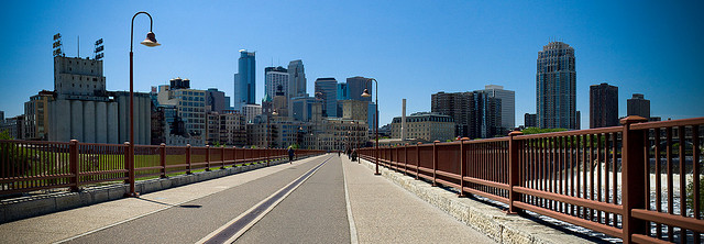
Minneapolis skyline from an empty bridge

There’s been so much noise made about the resurgence of cities that it’s easy to forget how many are shrinking in population. There’s been a lot of kvetching about what to do as one city loses people to another, or as people move to the suburbs. Detroit has become the poster child of the shrinking cities trend, and its dramatic decline has spooked some people into believing that the taste of many future cities will be laced with a dystopian sourness.

Shrinking cities are nothing new. Many East German cities lost thousands of residents following reunification with West Germany, and Pittsburgh and other American rustbelt cities have been declining for decades. Hell, most of Europe depopulated thanks to the Black Death. And while Detroit may be the most arresting modern example, it is by no means the only one. Still, there may be hope for cities that can’t seem to attract more residents. Two research papers suggest that while growing populations may help cities thrive economically, happiness may not depend on new bodies.

The notion that population growth is necessary to sustain residents’ happiness is a logical one. For one, no one likes being part of a losing team. When more people move out of a neighborhood than in, I’m sure it feels to residents like they’ve placed a bad bet. Also, there’s an economic argument that supports the link between population growth and happiness: With a larger tax base, cities can build more libraries, groom more parks, erect more museums, fill more potholes, and so on.

So it’s somewhat surprising that a new study found population decline can go hand-in-hand with residents’ happiness. The author juxtaposed changes in population with neighborhood satisfaction ratings for 38 major U.S. cities between two time spans, 1994-1998 and 1999-2007. Though some of the cities that shrunk saw their ratings decline (Cleveland, I’m looking at you), so too did a few the cities that grew. In fact, the city that had the worst change in satisfaction ratings (Anaheim) grew by more than 11 percent. Overall, the author did not find a significant difference between growing cities and shrinking cities.

The second study looked at the infamous shrinking East German cities. Seeking better opportunities, many East Germans have flocked to the former West. The author took general standard of living questions and tried to distill the effects of cities’ population trajectories on happiness, especially the differences between cities in the former East and West Germanys. Though Ossis are overall less happy than Wessis, the study found, there was no difference in happiness between growing and shrinking cities within either the East or the West.

Still, I’m not entirely inclined to believe these studies just yet. First, the American study examines a very limited—and oddly defined—period of time. Second, the tests both authors use to determine differences between growing and shrinking cities (a t-test in the American study and probably the same for the German one, though the author does not specify the test in the methods) is far from sophisticated, and a look at the American data tells me it’s probably not the most appropriate one, either. Finally, the use of neighborhood satisfaction in the American survey as a proxy for happiness—while clever—may not adequately capture the effect of city-level landmark institutions, such as San Antonio’s river walk. And the German study’s reliance on more general standard of living questions does not seem to isolate the role cities play in happiness.

There may be some truth to the idea that shrinking cities can contain happy people—after all, growing cities may also be more crowded, which can make people very unhappy—but I’m going to reserve judgement for now.

Sources:

Delken, E. (2007). Happiness in shrinking cities in Germany Journal of Happiness Studies, 9 (2), 213-218 DOI: 10.1007/s10902-007-9046-5

Hollander, J. (2010). Can a City Successfully Shrink? Evidence from Survey Data on Neighborhood Quality Urban Affairs Review, 47 (1), 129-141 DOI: 10.1177/1078087410379099

Photo by jbrownell.
O megalopolis, megalopolis! Wherefore art thou, megalopolis?

BosWash megalopolis

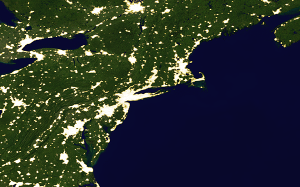
Twenty some years ago when I was leafing through my fourth grade social studies textbook, I became absolutely captivated by the idea of a megalopolis. “BosWash” was the one that really stuck in my head. The idea of one continuous city stretching from Boston to Washington, D.C. seemed unfathomable. Hell, downtown Milwaukee seemed big to me. But one city, stretching for hundreds of miles. It’s the sort of big thinking that grabs a nine year old and doesn’t let go.

Well it’s been twenty years, and I haven’t heard much about megalopolises in that time. If these agglomerations were really going to be the way many of us were to live, why haven’t we heard more about them? “BosWash” and “SanSac” have failed to enter the vernacular, though the Northeast or Northern California have continued to grow. So what happened to megalopolises? My hunch? They never went away—they merely became reality. Plain, boring reality.

BosWash and other megalopolises do not look like what a fourth grader would imagine a continuous city to be. They’re not a line of skyscrapers hundreds of miles long, or even a stream of townhouses and four-story office buildings. Instead, they’re just cities and suburbs stretching farther than the eye can see. My disappointment upon discovering the reality of megalopolises is not unlike to my reaction at learning the Pacific garbage gyre was not, in fact, an dense, walkable island of plastic the size of Texas.

Megalopolises and the Pacific garbage gyre have a lot more in common than just my own disillusionment. Both are larger than life, stirring our sense of awe (even if that awe is for how wantonly wasteful we are). Their realities are the sort that could never live up to our imaginations. Both are continuous, but also no where near as dense as we (or I) had imagined. BosWash is still five distinct major cities lodged in a matrix of smaller cities and suburbs. It sure feels continuous traveling between them, but it’s not all asphalt jungle between Boston and D.C.

Though megalopolises have slowly become reality, the word and the concept have been around for while. The original Megalopolis was an ancient Greek city smack in the middle of the Peloponnesian peninsula. It was a large city for the time (the Wikipedia article on the place mentions, not once but twice, that it had a theater that sat 20,000). Use of the term, especially as it pertains to large modern cities, didn’t become widespread until the early 1800s. The Oxford English Dictionary cites Webster’s American Dictionary as the first source of the word in 1828, meaning it had probably been a part of the lexicon for a number of years (aside: reading one dictionary cite another was a very “meta” experience). In 1927, Sir Patrick Geddes, a sociologist and city planner, whipped the term into its most current definition—a “city overgrown”—and London’s Daily Telegraph appropriately applied the epithet to Los Angeles forty-two years later.

In the intervening years, geographer Jean Gottmann intensively studied the United States’ Northeast megalopolis, helping cement the idea of a region-wide city in our social psyche. Futurist Hermann Kahn would name the region BosWash in 1967, a mere ten years before my social studies textbook was most likely published. Unfortunately for Kahn, the name didn’t stick, probably because it sounds kind of silly. Moreover, it fails to capture how the region has grown. Fingers of BosWash have extended north into Maine and south into southern Virginia, according to a 2005 Virginia Tech study (pdf).¹

Back in the 1960s, the notion of cities hundreds of miles long seemed so fanciful and future-friendly that it resonated with the zeitgeist. But as I think about the term today, it seems a lot less romantic. Yes, I’m not in fourth grade any more, and no, Boston, New York, and Washington have not slipped into decay. But what joins them is not a massive, continuous city, but a string of suburbs that just sort of popped into existence, suffocating the small towns in between. The anchor cities themselves still retain their particular character, which probably made fabricated name like BosWash feel, well, fabricated. The future will almost certainly bring many more megalopolises, but I’m guessing it will take a while before people cotton to the idea of being part of one giant city rather than a locality within a booming region. Until they do, the term “megalopolis” will probably remain relegated to academia and fourth grade text books.


  1. The same study rightly tries to do away with such constructions as “BosWash” and “SanSac” because they are unused, but then insists on calling region-wide cities “megapolitans” rather than “megalopolises,” despite its own finding that the latter is far more widely used than the former. So much for going with the flow.

Photoillustration by Tim De Chant. Images from NASA/Visible Earth.

“What if” development ran rampant in Silicon Valley?

Silicon Valley

Silicon Valley exploded in every way possible following World War II, well before it was known as Silicon Valley. The population boomed, houses were thrown up, and roads slithered out from the peninsula’s main drag, the El Camino Real. But as the strip malls started to take over, locals set about preserving much of the open space that remained.

Throughout the Bay Area, over 1,500 square miles have been protected from development. Some sprawl advocates such as Robert Bruegmann have suggested the sheer volume of protected land within the Bay Area has forced suburbs far into California’s Central Valley, and that the land closer to the city centers would be better used for housing. Silicon Valley itself holds a not-insignificant 181 square miles of the Bay Area’s protected land. Detractors claim the open space has hemmed in development too much, forcing additional housing elsewhere, increasing commute times, and reducing the amount of affordable housing in the Valley.

About the Finder easter egg

Even Apple engineers were enamored with the golden hills that surround Silicon Valley.

Such criticism can be difficult to deflect without ripping up woodlands and grasslands, so a group of geographers set about asking “what if” the protected land in Silicon Valley were open to development. They created a series of maps to predict where and how much development would take place by analyzing six characteristics—slope of the terrain, presence of wetlands, distance to streams, distance to railroads, and distance to historical urban centers—that would help them determine the number of additional houses each piece of land could support.

In total, they found that 51,000 additional housing units could be added in Silicon Valley if all the parks, protected watersheds, and protected wetlands were be converted to housing. For reference, the region has 790,000 units currently. Crucially, the study’s authors estimate only around 3,400 units would be on lots small enough to be considered affordable by Bay Area standards.

Topography is the main reason few affordable units would be added to the area’s housing stock. Much of the protected area in Silicon Valley is high in the hills and on steep slopes. Due to concerns over wildfires and mudslides, housing density in these areas is restricted. Existing houses built on unprotected wetlands have also been spaced far apart. Since the Valley’s large protected tracts are either up in the hills or down in the wetlands, there is little room for additional high density (and affordable) development. Over 20,000 of the additional units, they estimate, would be single family homes on large lots, around 1.6 acres each. Real estate of that size in the Bay Area is not cheap, even by Bay Area standards. Single family homes on one acre or larger lots in San Jose list for $1.5 million.

Six and a half percent more housing units might make a bit of difference in cramped Silicon Valley, but it would also do away with the open space that makes the area both livable and attractive to many. Plus, much of the gains in affordable housing would come at the expense of parks within city limits, many of which were created give residents of the surrounding high density housing a bit of fresh air and greenery. Sounds like it was a pretty good trade-off to me. Having worked with many high school students from such neighborhoods, I know many of them never made it to the Bay Area’s large regional parks. But they did spend many hours at their local neighborhood parks.

Source:

Denning, C., Mcdonald, R., & Christensen, J. (2010). Did land protection in Silicon Valley reduce the housing stock? Biological Conservation, 143 (5), 1087-1093 DOI: 10.1016/j.biocon.2010.01.025

Photo by calwhiz.

The map that started it all

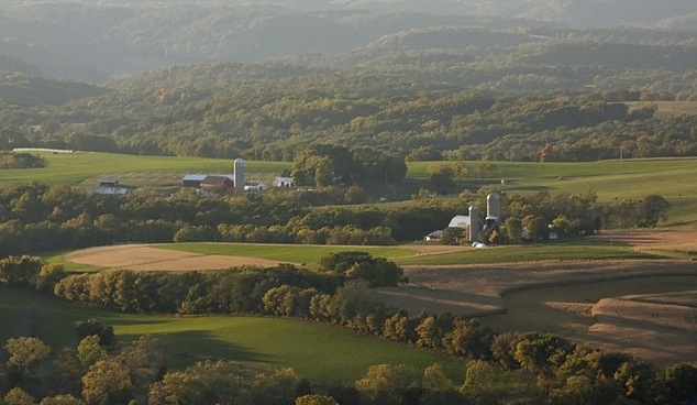
Blue Mounds, WI

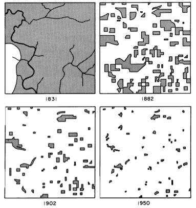
Buried in a dusty tome grandly titled Man’s Role in Changing the Face of the Earth lies a map that changed my life. Granted, my life was already headed in a direction amenable to this map’s wiles, but that lone figure’s influence cannot be understated. It is a simple map, or rather series of maps. Four panels, four dates—from left to right: 1831, 1882, 1902, and 1950. In each successive panel, the dark swaths of ink that represented forest cover in Cadiz Township, Wisconsin, grew successively smaller and more fragmented. In that one figure, John T. Curtis posthumously changed my life.

Cadiz Township, Wisconsin

Growing up in southeastern Wisconsin, I was always peripherally aware that the forest fragments I frequented had not always been mere fragments. But Curtis’s map drove the point home. His fragments were dead ringers for my fragments. His maps were my environmental awakening, but in black-and-white.

Curtis grew up in Waukesha, Wisconsin, the same place my grandfather lives. He attended Carroll College—also in Waukesha—for his AB and then moved 65 miles west to Madison for his PhD. Curtis more or less remained in Madison till his death in 1961, proving that you don’t have to go far to accomplish big things. Curtis is best known within the ecological community for his work with Roger Bray on ordination, a statistical technique that enables botanists to make sense of the distribution, frequency, and abundance of plant species on a plot of land. His Cadiz Township maps are almost an afterthought, a minor footnote in an otherwise sweeping treatise on Wisconsin vegetation.

Unlike Bray-Curtis ordination, the Cadiz Township maps are astonishingly simple. The figure’s earliest frame depicts a wild Wisconsin, untamed by the plow and dominated by a grand deciduous forest the likes of which I sought as a kid. The scene rendered fifty-one years later in the second frame is entirely different. The smooth curve of the prairie-forest border is gone. Inky shards replace the previously continuous forest. In the third map, those bits grow smaller still. In the 1950 frame, the remaining woodlots are barely visible, like the last specks of glass from a broken platter waiting to be swept into a dustpan.

What makes Curtis’s map all the more remarkable was that he recreated the scenes from survey data and his own observations, painstakingly piecing together handwritten records of the six-by-six mile township. To my knowledge, it is one of the first visual reconstructions of fragmentation-as-it-happened, and one of the most influential—at least to me.

Photo by Ron Wiecki.

Related posts:

If the world’s population lived in one city…

Parkland per person in the United States

Dissecting density

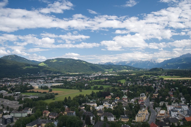
Salzachtal

Per Square Mile is a blog about density. It’s about what happens when people live like packed sardines. It’s also about what happens when people live so far apart they can go days without seeing another soul. It’s about living amongst trees and prairies and living in places miles away from them. It’s about the trees and the prairies, too. And lakes and streams and animals and insects. In short, this is a blog about density of all types.

I started thinking about density in earnest a little over six years ago when I moved to San Francisco from St. Paul, Minnesota. St. Paul itself was a big leap from my college days (small-town Minnesota) and my childhood (small-town Wisconsin), but it didn’t compare to what San Francisco held in store. At 17,323 people per square mile, bodies seemed to be crawling over each other. I couldn’t step foot outside of my apartment without seeing another person. That had never happened to me before, and it had a profound impact on the way I think about space.

Since then, I’ve pored over density figures for the places I’ve lived or considered living. Personal sanity is only a part of this obsession; environmental awareness is another. I moved to San Francisco for graduate school, specifically a PhD in environmental science. The coincidence of my study of landscape ecology and the shock of high-density living ended up being a happy one—the PhD process gave me the framework and background to thoughtfully consider my environs.

For years I have been debating with myself about the benefits of small town life—slower pace, open spaces, nearby wilderness—and the things I admire about big cities—mass transit, energy efficiency, and intellectual vibrancy. Up until now, these debates have been little more than daydreams and thought exercises. But with this here fancy blog, I intend to explore density more fully, both scientifically and philosophically. I probably won’t cover all there is to know about cities, towns, and their relationship with the natural world, but I might as well try.