All posts by Tim De Chant

Subtle but significant changes

A few days ago, if you were looking closely, you may have noticed a few changes here on Per Square Mile. A subtle tweak to the header, small icons for sharing instead of text or buttons, a date on features where there previously was none. But those only hint at much larger changes that have taken place under the hood.

Things have been a bit quiet around here for the past few weeks, and that’s in part because I’ve been working hard to revamp the site, making it fully responsive in the process. That means that you can now visit Per Square Mile from any device—from old 3.5” iPhones all the way up to desktop-powered 30-inch LCDs—and have a reading experience that’s been optimized for that screen size. You can see it in action if you’re on a desktop or laptop by resizing your browser window from largest to smallest. Go ahead, drag away. Every page on the site has been rewritten, from the homepage to individual posts and even the membership page.

I’ve tested the site on a variety of devices, from desktops and laptops to iPads and Androids, but of course I can’t test it on everything. If you see something that doesn’t look quite right, you know where to find me. In the meantime, I hope you enjoy this third major version of Per Square Mile.

A Short History of the Highrise

A beautiful production, but I find the “interactive” nature of the film series disruptive. Maybe I’m too linear when it comes to video, but I have a hard time getting back into the storyline after I’m done exploring. And I feel compelled to explore the extras because of their ephemeral nature (prompts only appear during certain parts of the video).

It would work better as an interactive first and foremost with the videos as features. That way you won’t feel like you have to explore the extras mid-sequence before they disappear.

A new class of city?

James Fallows, writing for The Atlantic:

By national standards Sioux Falls is small-ish, but it’s the biggest city in the state and has increasingly become the regional metropolis — the place where people come to do their shopping, get their medical care, and in many cases pursue their business ambitions.

What’s new here isn’t necessarily the phenomenon, but rather the cities that find themselves in this position. Today it’s Duluth, but yesterday it was Minneapolis-St. Paul. As population grows, once marginal cities take on new importance.

Making rail profitable

Eric Jaffe, reporting for the Atlantic Cities:

“Somewhere along the journey we split land values away from the railway operation, and the railway operation just became a railway operation, and they lost their property arm,” he said. “When you look at cities like Hong Kong, what they’ve done with their metro system, it’s fundamentally a property company. They built a metro system on the side. It’s there to increase values. We have to return to that. I think that’s what we’ve lost. That connectivity between the two things.”

Or like JR Rail in Japan, which owns plenty of real estate around its stations. Look how profitable they are.

Replacing the gas tax

Keith Laing, reporting for The Hill:

The chairwoman of the Senate committee that oversees infrastructure projects said on Wednesday that the federal government should replace its 18.4 cents per gallon tax on gasoline purchases with a fee that is paid by oil wholesalers.

Getting rid of the federal gas tax in lieu of a wholesale oil tax increase would help close an approximately $20 billion shortfall in transportation spending Congress is looking to solve, Sen. Barbara Boxer (D-Calif.) said.

Lidar comes to urban forestry

Liz McEnaney, reporting for the Architect’s Newspaper:

“The data goes beyond determining the amount of tree canopy,” says Jarlath O’Neil-Dunne, Director of the Spatial Analysis Lab. These maps are overlaid with census reports, demographics, property records, and other datasets that allow cities and not-for-profits to prioritize tree-planting efforts and tree maintenance plans, but also to understand patterns of environmental justice and to justify budget increases for urban forestry programs.

"Suburbia is not a place"

Justin Davidson, writing for New York Magazine:

Suburbia is not a place. It’s not even a specific genre of settlement. Rather, it’s a morally charged word that covers everything from densely packed single-family houses, interspersed with apartment buildings and shopping streets, to airy desert settlements, still with that new-turf smell. Like cities, suburbs include an immense range of pleasures and social ills. Unlike cities, they are chopped up into so many jurisdictions, micro-markets, and demographic eddies that one development can wither while the next one over crows. That creates an enduring problem: Who would pay to overhaul connector roads like Route 110? Fixing suburban dysfunction is nobody’s responsibility, so everyone just sits in traffic, certain that this is the way it has to be and that nothing will ever be done.

Extinction debts catch up quickly

Chiew Larn Reservoir islands

John T. Curtis, a 20th century ecologist, drafted a simple, four-panel map that appeared in a volume of research presciently titled Man’s Role in Changing the Face of the Earth. It’s an important map for a number of reasons, not least of which was the impact it had on my life. This is how I described it in my first non-introductory post here at Per Square Mile:

It is a simple map, or rather series of maps. Four panels, four dates—from left to right: 1831, 1882, 1902, and 1950. In each successive panel, the dark swaths of ink that represented forest cover in Cadiz Township, Wisconsin, grew successively smaller and more fragmented.

Curtis's map

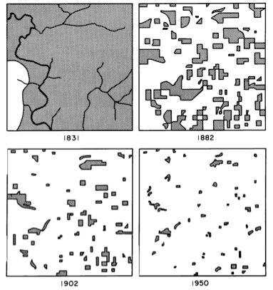
It’s a powerful image, one that drives home just how much we have affected this world. But like many images, there’s a lot that’s both implied and unknown. One of the unknowns of Curtis’s map was how life was faring in those small flecks floating in a sea of farm fields.

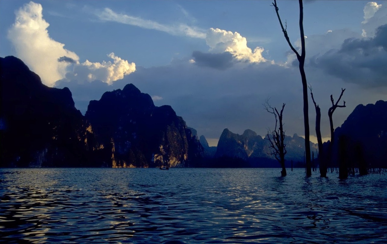
Now, we may be a step closer to understanding how dire that situation really is. A team lead by David Bickford, a professor at the National University of Singapore, recently wrapped up a 25-year study of forest patches turned into islands by the filling of the Chiew Larn Reservoir in Thailand in 1986 and 1987. The reservoir flooded nearly 64 square miles (165 square kilometers), isolating more than 100 patches of species-rich tropical forest. What had been hilltops were transformed into islands. Five to seven years after the flooding, the research team surveyed small mammal populations on 12 of the islands and 16 of the islands 25 to 26 years after.¹ None of the islands had signs of human impact.

Bickford and his team discovered that species vanished from the islands at an astonishing rate. Nearly all of the native small mammals were gone on the smaller islands (under 24 acres or 10 ha) in just five years, while on larger islands (24-138 acres or 10-56 ha), they were nearly extinct after 25 years. Their findings jibes with a message conservation biologists have been sharing for some time—the smaller the island, the fewer the species, and the longer the time since isolation from the mainland, the fewer species.

There are a number of possible reasons why small mammals disappeared from these islands, none of which are very heartening. The researchers point out that invasive Malaysian field rats were a problem on the islands, likely outcompeting or outright killing the native species. By the 25-year time point, “all islands were dominated by the invasive rodent and if not already in ecological meltdown, were well on their way to becoming Rattus monocultures,” Bickford and his team note.

But there are other possible reasons, too. Small habitat patches may not be large enough to sustain a viable population. When ranges are compressed, populations face a number of hardships, from increased competition for resources to inbreeding and intrapopulation strife that can raise stress, increase conflict, and lower breeding rates.

This study isn’t just about isolated islands in a remote corner of Thailand. It’s also about the flecks of land we cordon off every time we fell a forest, plow a field, or plat a subdivision. We’re creating small islands of habitat surrounded by seas of human dominance. Certainly some animals and plants can move between those islands, but not all do and not all at rates needed to sustain remnant populations. Some animals may be better than others at navigating human oceans, but even they may be doomed, unable to withstand competition or predation from introduced species. If we are to minimizing the impact we have on the environment—whether those be cities, farms, or even oil fields—we can’t just plan the land we’ll occupy, we have to plan the land we won’t.


  1. I would have liked to see a control transect on the mainland to see how the islands’ biodiversity compares, but they didn’t do that for whatever reason. (Perhaps they couldn’t find an area that wasn’t affected by humans.)

Image courtesy of Antony Lynam

Source:

Gibson L., Lynam A.J., Bradshaw C.J.A., He F., Bickford D.P., Woodruff D.S., Bumrungsri S. & Laurance W.F. (2013). Near-Complete Extinction of Native Small Mammal Fauna 25 Years After Forest Fragmentation, Science, 341 (6153) 1508-1510. DOI:

Related posts:

Nature’s burning library

Ghosts of ecology

Urban forests just aren’t the same

Architecture of Density

Viewed from these angles, high-density seems to overwhelm in Hong Kong. Anyone care to guess how many of these are subdivided?

Have-Nots Squeezed and Stacked in Hong Kong

Bettina Wassener and Grace Tsoi, reporting for the New York Times:

Hong Kong’s economy underwent a major change in the 1980s, when much of the manufacturing activity that made the city famous in the 1950s and ’60s moved across the border to mainland China. In its place came banking, insurance, trading, logistics and real estate — service sectors that now employ nearly 90 percent of the work force but that have been unable to absorb many less educated workers, Mr. Wong said.

At the same time, Hong Kong has some of the highest living costs in the world, a huge and growing burden on those at the bottom of the income ladder.

Think Japanese capsule hotels, but for long-term occupancy. They make micro-apartments appear spacious. Maybe Hong Kong needs to look underground, too.

Singapore Looks Below for More Room

Calvin Yang, reporting for the New York Times:

Building underground is not new in Singapore. About 12 kilometers, or eight miles, of expressways and about 80 kilometers of transit lines are below ground. Drainage systems and utility tunnels are common features beneath the urban landscape.

Now Singapore is going further, beginning work on a huge underground oil bunker called Jurong Rock Caverns. When this is completed, it will free about 150 acres of land, an area equivalent to six petrochemical plants.

Another project on the drawing board is the Underground Science City, with 40 interconnected caverns for data centers and research and development labs that would support the biomedical and life sciences industries. The science center, with an estimated 50 acres to be 30 stories below a science park in western Singapore, would house as many as 4,200 scientists and researchers.

27 years to get our house in order

The Economist:

For the first time, the IPCC has set what is usually called a carbon budget. To have a two-thirds chance of keeping global warming below 2ºC, it says, “will require cumulative CO2 emissions from all anthropogenic sources to stay between 0 and about 1,000 [trillion tonnes]”.

The world has already blown through just over half that amount (531 trillion tonnes) by 2011. At current rates of greenhouse-gas emission, the rest of the budget will have been spent before 2040.

Why is IPCC report so certain about the influence of humans?

John Abraham and Dana Nuccitelli:

Many commenters have noted that the expert consensus is itself not scientific evidence for human-caused global warming. That’s true. The expert consensus is however based on the scientific evidence. The fact that 97 percent of climate experts agree on this subject also demonstrates the strength of the scientific evidence on human-caused global warming. And the strength of the evidence is why the IPCC is able to say with 95 percent confidence that humans are the main cause of the current global warming.

What Happens When Natural Disasters Instantly Change Our Maps?

Alissa Walker, writing for Gizmodo:

The shifting boundaries between land and water can transform an area’s fortunes in an instant. When a coastline is altered, the habitats of the existing plants and animals can be destroyed, paving the way for new species to move in. It changes the game for people, too, as local residents now have different access to resources—for instance, losing farmland or gaining fishing coves.

If this isn’t evidence of new editor Geoff Manaugh’s influence, I don’t know what is. Gizmodo was in desperate need of a new direction before he started. So far so good.

Speedy Trains Transform China

Keith Bradsher, writing for the New York Times:

China’s high-speed rail system has emerged as an unexpected success story. Economists and transportation experts cite it as one reason for China’s continued economic growth when other emerging economies are faltering.