All posts by Tim De Chant

Your carbon footprint may not be as low as you think

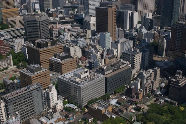
Tokyo buildings

High-density living—it’s an urbanist’s answer to climate change. Living close is a straightforward solution to a complex problem. One that’s probably a little too simplistic. While living in dense cities certainly does reduce your carbon footprint, the results may not be as dramatic as you suspect.

That’s according to a new research paper by Chris Jones and Dan Kammen, two University of California, Berkeley researchers who have extensively studied people’s carbon footprints. Their results show that moving from a carbon-heavy suburb to an ultra-dense city will only reduce your emissions by 35 percent on average. Yes, that’s a big number, but perhaps not as significant as we’re often led to believe. But fortunately lurking within their data is an even simpler—and maybe even more effective—way for metro areas to reduce their footprint.

Jones and Kammen have spent years honing their methodology for determining people’s carbon footprints. Jones is the lead scientist at the Renewable and Appropriate Energy Lab and Kammen is its director and a professor at the university. Together they’ve created one of the most detailed and accurate carbon footprint calculators available online. To develop that tool, they had to ask a lot of people a lot of questions about their lifestyles. With that experience, they’ve published a number of papers that lift the veil on our energy use, revealing which aspects of our lives produce the most greenhouse gas emissions.

Their latest paper is contains some seemingly unexpected results, all gleaned by modeling emissions for individual ZIP codes. For example, you might expect carbon footprint to fall commensurately with population density. After all, living in the boonies makes you pretty reliant on cars while living in the city frees you to take transit. But it isn’t so clear cut. People living far from cities and suburbs have fewer destinations and tend to buy less, driving down their overall footprint.

As population density increases, then, household carbon footprints rise initially, up to 3,000 people per square mile. After that point, emissions per household drop, though the trend isn’t linear, it’s logarithmic, which is to say it falls fast at first but then with plateaus.

Jones and Kammen found that the most carbon intensive places to live are about 15 to 45 miles from the center of the nearest major city.¹ Most households in these bands have higher incomes and more members, both of which are tightly coupled with carbon emissions in the U.S. Those households also have higher transportation footprints—50 percent more than city center households. Overall, suburbs account for half of the U.S.’s carbon footprint. Large cities contribute 30 percent.

No city can escape its suburbs. As long as people have the means and the desire, they’ll live in those sorts of places. So to reduce a metro area’s overall carbon footprint, Jones and Kammen say, you have to tailor solutions that will work for each region of the country and each part of the metro. To be successful, those solutions must work with people’s existing behaviors.

Take the suburbs, for example. “These locations are ideal candidates for a combination of energy efficient technologies, including whole home energy upgrades and solar photovoltaic systems combined with electric vehicles,” they write. Forcing someone to use transit changes their behavior, and people are resistant to that. But if you encourage them to use electric cars, that works within their existing behavior. It’s an easier sell.

The overall trend of population density and household footprints offers another option, too. Pushing densities above 3,000 people per square mile can lower emissions substantially. That’s the tipping point in Jones and Kammen’s curve. Beyond that, they declined sharply, but then plateau. In other words, to make an significant impact, we just have to live a little closer together.


  1. The lowest emission rural areas are on par with people living in some major cities, though the densest cities still have the smallest footprints per capita.

Related posts:

Tell me how much you drive, and I’ll tell you where you live
What’s more energy efficient, shopping online or in stores?

If the world’s population lived like…

Japan offers to lend US half the cost of 'Super Maglev' train between Washington and Baltimore

Julian Ryall, reporting for The Telegraph:

Tokyo is so keen to show off its technology that it will provide loans for half the estimated $8 billion (£5bn) cost of installing the tracks, Japan’s Asahi newspaper said on Tuesday.

Masahiro Nakayama, a general manager at Central Japan Railway Co, told The Daily Telegraph that the American federal government was keen, and that the state authorities were especially enthusiastic about the project.

That’s nice, but just like the hyperloop, it glosses over the cost of land acquisition, which will surely dwarf the cost of the loan.

Urban Nature: How to Foster Biodiversity in World’s Cities

 Richard Coniff, reporting for Yale e360:

Though it may be too soon to call it an urban wildlife movement, initiatives focused on urban biodiversity seem to be catching on. The U.S. Forest Service, which once laughed off the idea that anything urban could be wild, now supports a growing urban forest program. Urban ecology and urban wildlife programs are also proliferating on university campuses. There’s a “Nature of Cities” blog, launched in 2012. University of Virginia researchers recently announced the beginning of a Biophilic Cities Network devoted to integrating the natural world into urban life, with Singapore, Oslo, and Phoenix among the founding partners.

Good news all around. But we don’t have to wait until city hall takes action—we can start with our yards, no matter how small.

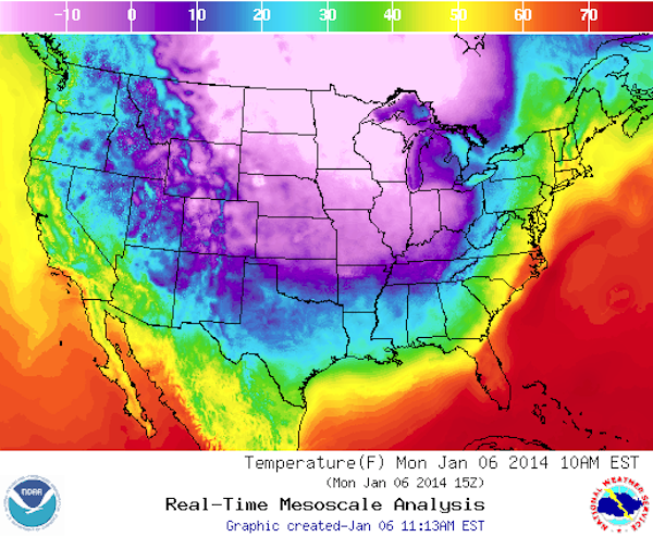
50 degree temperature swing in 48 hours

When I drove to work today, it was 59˚ out. Yesterday at the same time it was 27˚, and the day before it was 10˚. Meanwhile, it’s -16˚ in the town where I grew up in Wisconsin. Usually, we’re no more than 10˚ different.

Welcome to the future, everyone.

T2_conus

Two Decades of Change Have Boston Sparkling

Katharine Q. Seelye, reporting for the New York Times:

Boston’s boom was driven in part by a new dynamism among its universities and research institutions as technology expanded and the knowledge-based economy developed. Those institutions had always been here, but as Paul Grogan, the president of the Boston Foundation, which provides grants to nonprofit organizations, put it, “The world changed in a way that assigned a new value to them.”

How Much the Government Would Have to Spend to Make Public College Tuition-Free

Jordan Weissmann asked a great question: How much would it cost to make a college degree at public universities free? $62.6 billion. That sounds like a lot, until you read this:

If we were we scrapping our current system and starting from scratch, Washington could make public college tuition free with the money it sets aside its scattershot attempts to make college affordable today.

In 2013, the government spent $69 billion on various aid programs. Granted, those include money paid to students at private colleges; Weissmann’s figure of $62.6 billion would only cover public schools. But if the point is to provide an affordable college education, does that really matter?

Startup to launch 28-satellite Earth-observing constellation

Not sure how I missed this one, but Planet Labs, a startup called founded by NASA alumni, is planning to launch a 28-satellite constellation in the coming weeks that will take 3-5 m images of the Earth. That’s not a groundbreaking resolution, and I haven’t heard anything about return time. But given the number of satellites, it should be a good product.

Plus, there doesn’t appear to be any restrictions on who can buy the data, something that isn’t always the case with other satellites partially built using defense money. Cost per image is still unknown. (Some outlets, including the New York Times, have reported that Planet Labs will be providing imagery for free. I can’t find any evidence of that apart from a note on their site about the data being “open,” which is different than “free.”)

Saving Suburbia

Adrienne Berard, writing for Nautilus:

As environmentalists strive to build more eco-friendly burbs, they are producing an unexpected benefit: Their greener houses lend a visual diversity to a residential model that has remained largely unchanged since the 1950s. Green houses are developed with their surroundings in mind, which means that green suburbs may one day vary dramatically from one part of the world to the next.

I think Berard has hit on something that goes unmentioned in her article—that suburbs could be testbeds for all sorts of sustainable building technologies. Cities are somewhat insulated from energy shocks—shared walls in high-rises literally act as insulation. Plus, the demands of high-density living dictate a compact use of space and materials.

But in the suburbs, there’s more room to experiment. Once the kinks get worked out, those technologies and techniques can move to the city.

John Kerry tries a different tack

Coral Davenport, reporting for the New York Times:

In his first year as secretary of state, Mr. Kerry joined with the Russians to push Syria to turn over its chemical weapons, persuaded the Israelis and Palestinians to resume direct peace talks and played the closing role in the interim agreement on nuclear weapons with Iran. But while the public’s attention has been on his diplomacy in the Middle East, behind the scenes at the State Department Mr. Kerry has initiated a systematic, top-down push to create an agencywide focus on global warming.

I wonder how this will play into the Keystone XL decision. Maybe giving the final say to the State Department wasn’t such a bad idea after all.

Landsat at your fingertips

Jesse Anttila-Hughes points us to the USGS’s new Landsat data browser. It’s surprisingly fast, and the ability to scroll back through time is amazing, though by using it you become acutely aware of the changes in sensor resolution that happened over the years. My only gripe? That scrolling doesn’t zoom in and out, like it does on most web mapping platforms.

Mapping Course and Software Make Forest Monitoring Widely Accessible

Yale e360:

New software that uses satellite technology to map and monitor changes in forested areas is being made available to the public through a free online course. Users who complete the course, hosted by Stanford University, can receive a license to operate the software, called CLASlite. CLASlite, or the Carnegie Landsat Analysis System lite, is a highly automated system for converting satellite imagery from its original, raw format into maps that can be used to detect deforestation, logging, and other environmental disruptions.

Curious to see if this catches on. I can see arguments for and against restricting the software to people who have completed the MOOC—better data, but fewer users. 

How Los Angeles Erased Hills From Its Urban Core

Nathan Masters, writing at Southland:

In 1912, Los Angeles considered an audacious plan to reshape its topography. A group calling itself the Bunker Hill Razing and Regrading Association proposed to pump water from the Pacific Ocean, pipe it 20 miles to the city center, and spray the seawater through high-pressure jets against a ridge of hills to the immediate northwest of downtown Los Angeles. In all, the project would sluice away some 20 million cubic yards of shale and sandstone that residents knew as Bunker and Fort Moore hills.

Ultimately dismissed as impractical, the association’s plan was only the first of several schemes to erase the hills from the city’s landscape. In the late 1920s, before the Great Depression intervened, the city came close to adopting another plan by C.C. Bigelow, a mining baron well-versed in the art of hydraulicking.

Think of how different LA would look today if it still had those hills. Never underestimate the power of topography in shaping a city’s character.

Cows might fly

If you read one thing today, check out Veronique Greenwood’s thoughtful, engaging rumination on how space and density affect everything from agriculture to social values. I’d link to this piece even if she hadn’t namechecked me. 

A taste:

Can we develop this kind of ethos in countries that aren’t Switzerland? One day in October, I tossed around the idea with my father, an ecologist from Massachusetts, and the Valaisan farmer Charles-André Mudry, his wife, Doris, and their son Xavier. When they are not at the alpage, they live in the town of Lens, reachable by a bus that crawls in a determined zig-zag up the steep valley wall. Mudry had just come in from selling a calf; Doris, who told me about fashions in cow naming, served tea and cookies.

Xavier suggested that in terms of political structure, the US and Switzerland are not so different: each has states and a central power. But we kept coming back to the enormity of the difference in size. My father pointed out that you can see the high mountains from Sion, the capitol of Valais. You cannot see Wisconsin from Washington. And the tradition in the US (such as it is) is to change the use of the land without regard to the past or the long-term effects, if that’s what market forces demand.

‘Where I grew up, 100 years ago, 150 years ago, it was an agricultural landscape. Now it’s forest,’ my father said. ‘It was all changed by the production in the West … There are walls that cross the forest. You can see that clearly, there were fields here, 100 years ago. We have a past, but it disappears before we can take the measure of it.’

How Bacteria Will Make Our World Cleaner and Healthier

Yours truly, writing at NOVA Next:

Like many ideas whose time is right, Jansson wasn’t alone in her foray into the human microbiome. “There were several soil microbiologists that started to do the same thing as me. Just independently, without knowing,” she recalls. “At that time, methods-wise, technique-wise, the environmental field was farther ahead than the clinical field, whereas in the past, it has been the reverse.”

That reversal would end up changing the way we understand the microbial world. Rather than assuming bacteria and other microorganisms lead lives that occasionally intersect with the macroscopic world, we would come to learn that microbes exert their influence in various and surprising ways. But as we discover more about the remarkable diversity in the microbial world, we’re learning that we may be able to use them as allies in everything from advanced medical treatments to farming and environmental remediation.

Zipf's Law

Annalee Newitz:

Back in 1949, the linguist George Zipf noticed something odd about how often people use words in a given language. He found that a small number of words are used all the time, while the vast majority are used very rarely. If he ranked the words in order of popularity, a striking pattern emerged. The number one ranked word was always used twice as often as the second rank word, and three times as often as the third rank. He called this a rank vs. frequency rule, and found that it could also be used to describe income distributions in any given country, with the richest person making twice as much money as the next richest, and so forth.

Later dubbed Zipf’s law, the rank vs. frequency rule also works if you apply it to the sizes of cities. The city with the largest population in any country is generally twice as large as the next-biggest, and so on. Incredibly, Zipf’s law for cities has held true for every country in the world, for the past century.

Offshore fresh groundwater reserves as a global phenomenon

Vincent E.A. Post, et al., writing in Nature:

The flow of terrestrial groundwater to the sea is an important natural component of the hydrological cycle. This process, however, does not explain the large volumes of low-salinity groundwater that are found below continental shelves. There is mounting evidence for the global occurrence of offshore fresh and brackish groundwater reserves. The potential use of these non-renewable reserves as a freshwater resource provides a clear incentive for future research. 

Good news, though the non-renewable part shouldn’t be overlooked.

How Did A Small Illinois Town End Up With 300 Plug-In Cars?

Stephen Edelstein, writing for Green Car Reports:

The Mitsubishi i-MiEV is a common sight in Normal, which is home to the Mitsubishi plant that produces a gasoline model from the Japanese maker.

Normal used federal grant money to buy 48 240-Volt Level 2 charging stations and one DC quick-charging station, which uses the CHAdeMO standard.

In addition to the town-owned stations, Normal also leases four of Tesla Motors’ Supercharger quick-charging stations from Tesla Motors.