Your images of income inequality, seen from space

https://persquaremile.com/wp-content/uploads/2012/06/

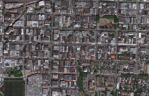
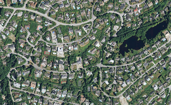
A month ago, I covered a study showing how tree cover was related to income level. A couple of weeks later, I posted images gleaned from Google Earth showing how easy it is to spot income inequality from space. I also asked you, my readers, to send me more examples of the same.

The response has been overwhelming. In fact, I’m still receiving emails and comments. I haven’t been able to go through them all, so if yours isn’t below, hang tight. I’ll get to it eventually. Consider this a post that’ll be updated continuously. As they say, check back early and often.

So without further ado, here they are. This is where you see income inequality. You may see it every day, right in your own backyard. You may have stumbled across it years ago. You may have noticed on a vacation. But collectively, you see it everywhere. Keep ’em coming.

Mexico City

From Todd Gastelum, who writes:

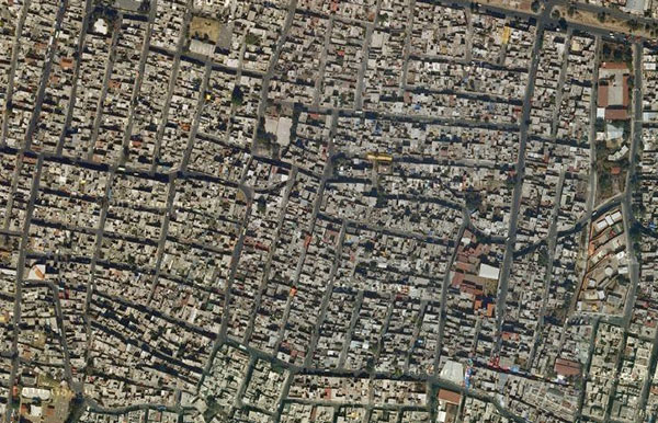
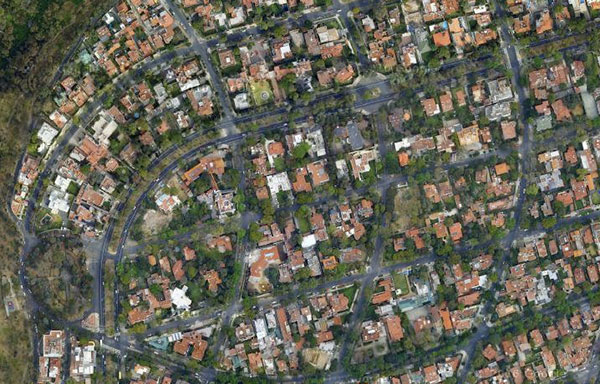
Although it appears that these satellite images are presented at different scales, I assure you that they were not. The houses in Lomas truly are enormous whereas San Miguel Teotongo is typical of the dense, irregular urbanization characteristic of the city’s more peripheral zones.

Lomas de Chapultepec, Miguel Hidalgo
San Miguel Teotongo

San Miguel Teotongo, Iztapalapa

Lomas de Chapultepec

Dar es Salaam, Tanzania

From Aaron Krolikowski, who writes:

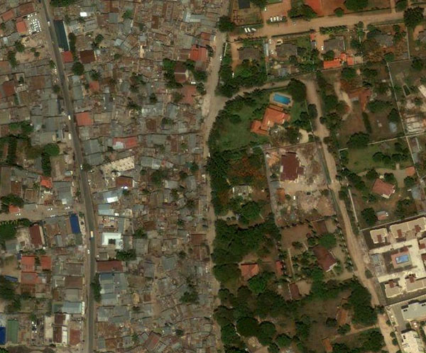
I’m a PhD student (in Geography) from the University of Oxford. My work takes place in Dar es Salaam, Tanzania and I spend quite a bit of time looking at maps of the city. One of the first things I noticed was exactly what you mention in terms of the ability to see income inequality from a birds-eye view. I’ve shared some photos with you to give you an idea of what I look at (and live!) every day here.

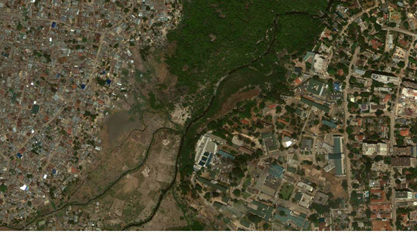
The first – To the left you have unplanned settlements of “Mikoroshini” and “Makangira”…to the right, the highly affluent and very European “Oyster Bay”

The second – To the left is the informal settlement of Hanna Nassif and across the river is middle-class Upanga

Mikoroshini, Makangira, and Oyster Bay
DaresSalaam

Hanna Nassif and Upanga

DaresSalaam2

Vancouver

From Sylvian Paradis.

Downtown East Side
Downtown East Side

British Properties
British Properties

Lisbon, Portugal

From João Jordão.

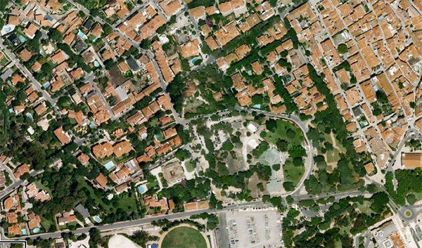
Cova da Moura, Amadora
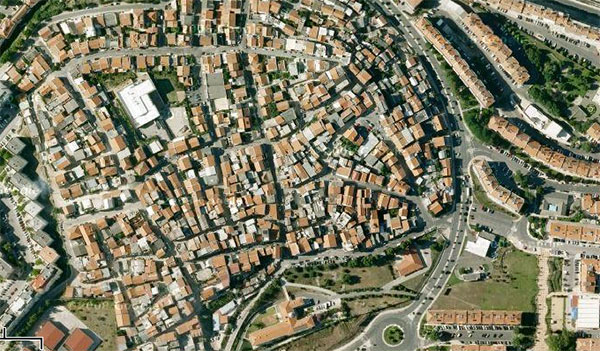
Cova da Moura

Cascais

Cascais

Why you should be excited about vector-based maps in iOS 6

iOS vector-based maps

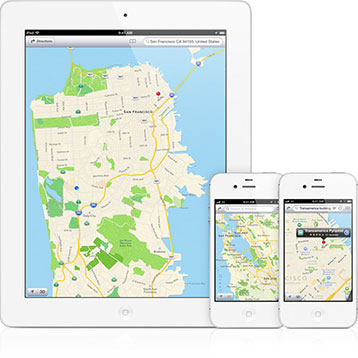
Apple announced today that it’s revamping the Maps application on iOS devices—iPhone, iPad, iPod touch—introducing a lot of showy new features like turn-by-turn directions and 3D flyovers. While those make for sexy commercials, they won’t be as impactful as the switch from raster- to vector-based map data. If you’re not sure why you should be excited about the change—and you should be—read on.

Web mapping has revolutionized cartography, but from a data perspective, it’s still stuck in the past. Google Maps, MapQuest, and others deliver map data as images. From a computer’s perspective, they’re just like photos snapped by digital cameras. They’re a series of pixels that combine to form an image. That means they’re well suited for web browsers, which are adept at displaying image files.

But that same strength is also a weakness. Image files can have either small file sizes or high levels of detail, not both. To compensate, web mapping applications load a series of tiles based on the extents of your view and how closely you’re zoomed in. Drag the map or zoom further, and they load more tiles to show more of the map or provide more detail. That trade-off has worked well in a broadband world, but it begins to show some cracks on mobile devices, which have more limited bandwidth.

Enter vector-based maps. They’re nothing new—geographic information systems have been storing and displaying vector data for decades—but their application in consumer mapping systems is. Vector data is stored as a series of lines and points instead of pixels. That means the only data stored is the data that matters. A vector street map, for example, will have data only on the streets’ paths, resulting in a smaller file. A raster map of the same also would have data representing the blocks in between the streets, even if they are empty, creating a larger file.

Another benefit of vector data is that it is just as precise at the widest zoom as it is at the closest. That eliminates the need for loading more tiles as you zoom in or out. It also means the entire data set—all scales, all extents—can be lighter-weight than a comparably detailed raster data set. That means map data can be sent more quickly to your iPhone. And it’ll look better—no more jagged boundaries if you happen to slip in between the zoom levels predefined by Google.

Vector-based maps aren’t a panacea, though. They’re simply not an option when it comes to displaying satellite photos—raster data is the only real choice for that. Plus, vector maps tend to require more processing power to display than raster maps. As a result, vector maps weren’t feasible on mobile devices until recently.

Those hurdles have disappeared in the past few years, at least for apps running on mobile devices. Google rolled out a vector-based maps app for Android in December 2010, and now that Apple has joined the party, it’s clear vector maps are here to stay. That doesn’t mean raster maps will disappear—satellite photos are still best viewed that way, and desktop and laptop users will be stuck with raster street maps for a while longer because of shortcomings of today’s web browsers. But mobile users—who have the most to gain at this point—will see immediate, though maybe not immediately apparent, benefits.

Photo courtesy of Apple.

Density and transit

Charlie Gardner plots some trends of density and the percentage of people who travel using mass transit. Unsurprisingly, high density cities have higher mass transit use, though there are a few notable exceptions.

Count the trees

Theresa Riley interviews yours truly on my urban trees and income inequality series for Moyers & Company.

Learning from Munich's Olympic architecture

Cristiana Strava, writing for Polis:

Speaking at the Legacy Conference in November 2002, current International Olympic Committee president Jacques Rogge criticized Olympic “luxury” projects that would become “white elephants” after the games, preferring developments that would prove sustainable afterward. After Beijing hosted the games four years ago, it became clear that the race to the top in terms of Olympic spending was spiralling out of control. In this moment, it is worth looking back and taking stock of the transformative effects the 1972 Olympics had on Munich, a city in the midst of re-inventing itself.

Ray Bradbury never gave up on monorails

Adrian Glick Kudler found this wonderful quote from the late, great master of science fiction:

 “A single transit line will not answer our problems; we must lay plans for a series of transportation systems that would allow us to move freely, once more, within our city. The answer to all this is the monorail.”

Hear, hear.

What is nature, now?

Christopher Mims:

To a significant extent, it’s us. It’s our machines — the hybrids of flesh and technology that we have all become.

I don’t mean to be cavalier about the damage we’re doing to our planetary life support systems. But any attempt to talk about the 21st century without acknowledging that every living thing on the planet will be altered by humans is intellectually bankrupt. There is no “nature” left — only the portion of nature that we allow to live because we imagine it serves some purpose — as a thing to eat, a place to reprocess our waste, or an idea that fulfills our dwindling desire to maintain “the natural” for aesthetic or ideological reasons.

Go outside

Jonah Lehrer:

From 2006 to 2010, the percentage of young children regularly engaging in outdoor recreation fell by roughly 15 percentage points.

This shift is occurring even as scientists outline the mental benefits of spending time in natural settings. According to the latest research, untamed landscapes have a restorative effect, calming our frazzled nerves and refreshing the tired cortex. After a brief exposure to the outdoors, people are more creative, happier and better able to focus. If there were a pill that delivered these same results, we’d all be popping it.

And:

What this research suggests, however, is that we need to make time to escape from everyone else, to explore those parts of the world that weren’t designed for us.

Or stated differently, we need to explore the parts of the world for which we have evolved. Early humans cut their teeth on the challenges of the natural world, so it makes perfect sense that our minds are sharpest and most creative when we are immersed in wilderness. The question is, in an increasingly urbanized and networked world, how do we maintain that connection? As Lehrer suggests, wilderness retreats are one way, but they’re just not possible for everyone. What we need to do is bring more wilderness to us.

How? Plant trees. Set aside more and larger parks. Give people better views out their windows. Those are all good places to start. But more important, I think we need to fundamentally reconsider how we incorporate nature into urban spaces.

Is humanity pushing earth past its tipping point?

Brandon Keim, reporting for Wired:

“There are some biological realities we can’t ignore,” said paleoecologist Anthony Barnosky of the University of California, Berkeley. “What I’d like to avoid is getting caught by surprise.”

David Quammen on Twitter

David Quammen is one of the best science and nature writers around, and he’s just joined Twitter. If you’ve got an account, click the link above and then press that follow button. You won’t be sorry.

If you’re unfamiliar with Quammen’s work, I suggest starting with Song of the Dodo. It is an incomparable piece of reporting and writing that, in part, inspired me to become an ecologist and a writer.

Why I can’t move back to Wisconsin

Forward?

I’ve often wondered if I would ever move back to my home state of Wisconsin. It’s not the logistics that phase me—I’ve lived in California, Illinois, and Massachusetts in the last three years. No, I’ve wondered whether the state could lure me and my wife with promising and satisfying jobs to complement the state’s kind people and bucolic countryside. Yesterday, I learned that will never happen.

It was yesterday that Governor Scott Walker survived a recall election. The contentious recall was spurred by his decision to strip public employees of their collective bargaining rights, the majority of whom are teachers.¹ Walker sold the move as a way to balance the budget, but really he was just codifying the shift in Wisconsin’s values that has occurred over the past few decades. It also betrays Wisconsin’s uncertainty about how to deal with the future.

Wisconsin, like many rust belt states, has had a difficult time finding its economic footing ever since off-shoring became de rigueur among manufacturing companies. It’s had a few chances since then, but none more promising than the biotech opportunity that slipped through its fingers. The University of Wisconsin was a pioneer in stem cell research. Had George W. Bush not restricted funding for stem cell research, Madison could have been an incubator for related startups, enabling the state to shrug off its manufacturing past. It was a rare glimpse of an alternate future. The loss of that future should have galvanized public and private investments in education and research to unearth the next big opportunity. Instead, Wisconsin gave up. Frustrated, it turned to a simpler and shorter-term solution—tax breaks.

What the state really needs is a complete economic overhaul. Tax breaks won’t accomplish that. That’s not to say tax breaks don’t have their place. They can entice established businesses to relocate. They can encourage existing ones to hire a few more workers. They can even help fledgling businesses gain a foothold. But they won’t create the kind of daring and brilliant entrepreneurs needed to reshape Wisconsin’s economy.

No one ever started a revolutionary company because of tax breaks. Disruptive companies are founded because someone has a fantastic new idea, not because the state offered them a few thousand dollars. They succeed because they can hire intelligent, well-educated employees, not because they are paid to increase headcounts. Such transformative companies don’t magically appear because of low taxes. They bubble up in places that value education and innovation.

Wisconsin is a state adrift. Where it used to be an agricultural and manufacturing powerhouse, today it is neither. It has no defining industry, no discernible direction. Wisconsin is trying to rediscover its economic muse, but it’s going about it in all the wrong ways.

Wisconsin could still find its way by pouring money into education. That in turn would encourage the sorts of crazy innovation that happens across the street from places like Stanford and MIT. By offering its best and brightest more than just friendly faces and a low cost of living, it could keep them at home rather than lose them to other states. These changes won’t happen over night—Silicon Valley’s success took years, even decades, to manifest—but they could happen.

Yet I know they won’t. Deep down, I know I will never be able to move back to Wisconsin.


  1. Well, some public employees. Police and firefighters retain theirs.

Photo by CindyH Photography.

An atlas of suburbanisms

Nate Berg:

To develop a better understanding of the ways that elements of urbanity and suburbanity go beyond their traditional boundaries, Moos and his team have launched the Atlas of Suburbanisms, a resource-rich website focusing on 19 cities and suburban regions across Canada. By mapping characteristics commonly associated with suburbs, the atlas provides a more nuanced look at how elements of suburbanism are actually dispersed in Canada’s metropolitan regions.

Like cities, not all suburbs are created equally. Or, for that matter, have evolved equally.

San Francisco's latest tech bubble

Norimitsu Onishi, reporting for the New York Times:

At the Ironwok Japanese and Chinese restaurant, whose half-torn storefront banner flapped in the wind on a recent afternoon, the owners were waiting for Twitter with the same mixture of expectation and trepidation shared by much of the city toward the second tech boom in a little over a decade.

“Of course, Twitter is good for the city, but how about me?” said the owner, Jenny Liu, 41, explaining that her landlord was raising her monthly rent to $12,000 from $8,000.

Having just spent last week in the Bay Area, including a few days in the city itself, I can understand Liu’s conflicted feelings. While the economy has tanked in much of the country, the Bay Area tech scene has bucked the trend with a vengeance. Many have benefitted, but it’s also made the region—which was already exceedingly costly when I left three years ago—even more expensive.

There’s heaps of opportunity for San Franciscans in a new tech boom, especially one where the epicenter is in the city and not the ‘burbs of Silicon Valley. But rents and real estate prices for all types of properties have risen substantially over the past few months. It’s possible that high prices will force out non-tech residents, who haven’t reaped quite as much from the recent boom. If that happens, San Francisco runs the risk that it will become a tech monoculture, depriving the city of the creative diversity that has spurred so much innovative and entrepreneurial spirit.

The upside is that this latest bubble could burst, which isn’t much of an upside at all.

The Internet in 1988

Technically it’s a map of ARPANET, the precursor of the Internet, but it’s still remarkable how small it was then and how large it has become in such a short time.

Thanks to Eric Fischer for finding another gem.

The yin and yang of conserving land

Felicity Barringer, writing for NYT Green:

Acquisition is the yin of conserving land. But increasingly, as I reported in an article in Sunday’s paper, much of the time and money that private land trusts have devoted to acquiring land is being diverted to defending the conservation restrictions they have already put in place.

The yang of conservation is the need to guard what has been given to future generations.

Greenbelt Mapper

I’ve long admired the Greeninfo Network’s cartography, and this webGIS that identifies open space at risk of being overrun by development is no exception. My only quibble is that it’s limited to the San Francisco Bay Area. Every region should have one of these.

Via Jon Christensen.